UAV Flight Demo showing Display of LIDAR Terrain Data: 11/18/2017
Demo Overview
The objective of this demo activity was to develop a custom iOS Ground Control Station
(GCS) for a DJI UAV (specifically a DJI Phantom 3 advanced) showing Terrain information
relative to the altitude of the UAV.
Test Flight Environment Overview
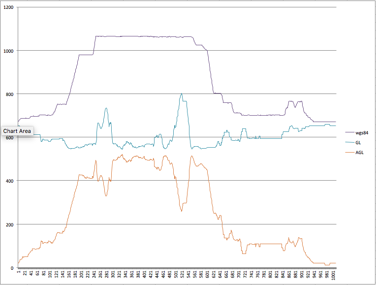
- UAV: DJI Phantom 3 Advanced
- Flight Speed (MPH) : 15 MPH
- Flight Altitude(Feet about Takeoff Altitude) : 250'
- Takeoff Altitude (WGS84 feet) : ~750'
- River Altitude (WGS84 feet) : ~600'
DJI Custom GCS View Video
GCS Configuration
- Apple iPad Pro
- Left View: Custom GCS Application
- Utilization of DJI API's to communicate to the UAV
- Utilization of UTM-like Web Service API's to communicate to the UTM-like Server
- Post Telemetry
- Get TerrainData
- Right View: Custom UTM FlightView Application
- Utilization of UTM-like Web Service API's to communicate to the UTM-like Web Server
- Get Telemetry
- Get TerrainData
- Local Services
- AC to AC Conflict Detection
- Flight Data Mirror
- Terrain Overlay Mgmt
- Aircraft Simulator
UTM
UTM Configuration
- Apple Macbook Air
- UTM-like Webserver providing UTM Web Services
- UTM FlightView Application
Vertical Profile